Exactly what you see.
ChronAlert pulls dozens of live public feeds onto one screen - every one of them listed below. Each feed can appear on the map, as an information card, or both, and you choose which are on. Nothing here is a subscription: the data is free, and so is everything except the Pro items noted.
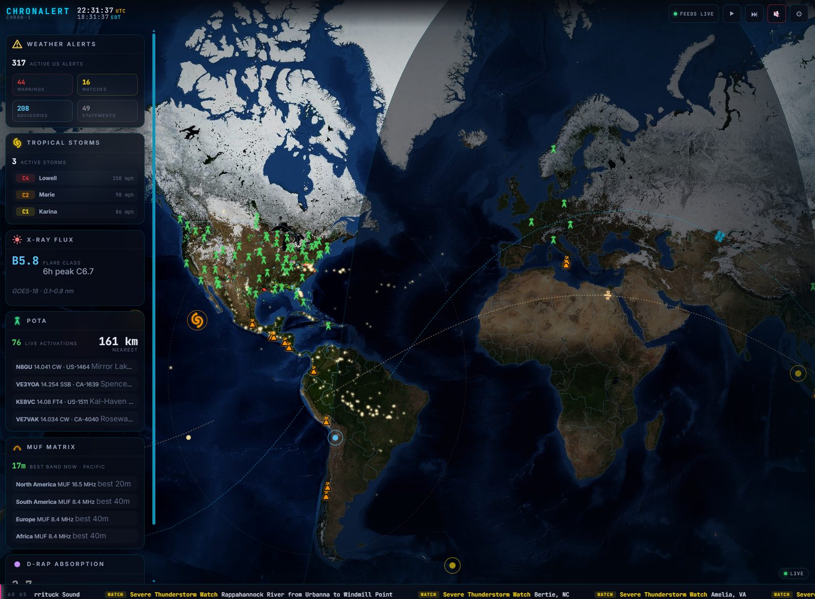
Zoom to whatever matters.
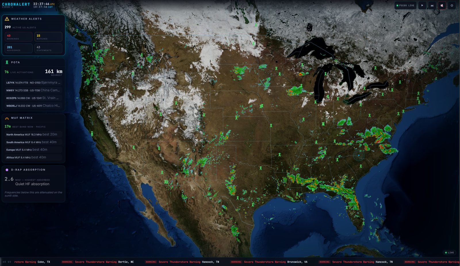
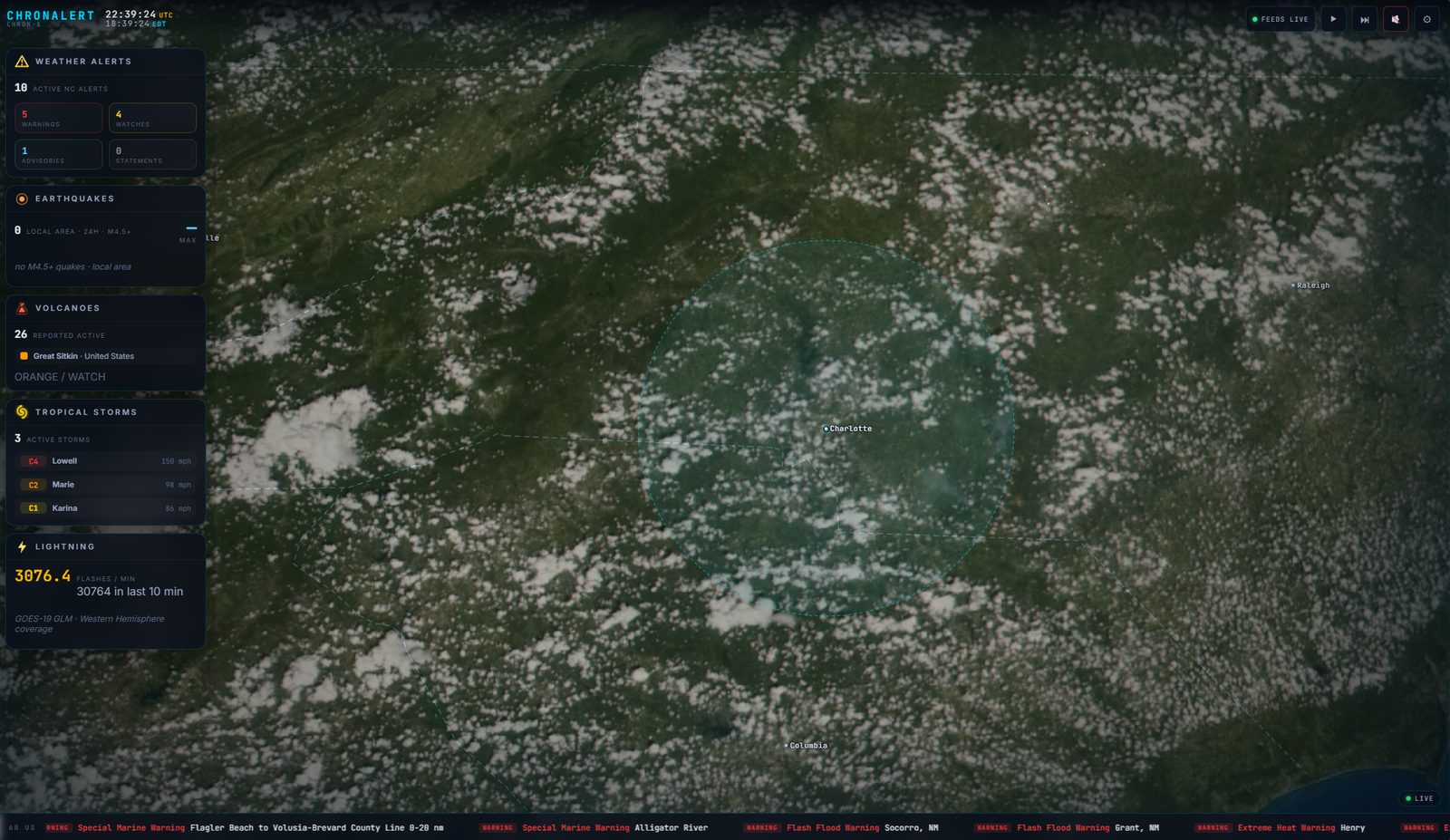
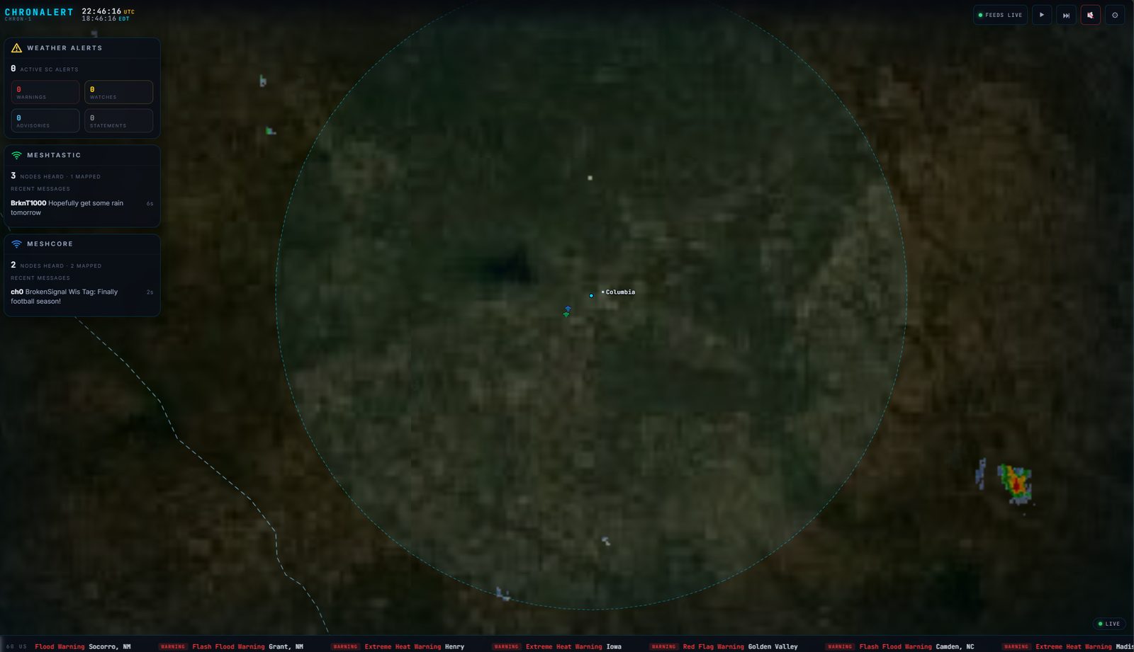
Every saved panel picks one of these. World, your National view, Regional, and Local are all in the free version; each view's zoom is configurable, and Regional / Local are a radius (in miles) around the location you set.
World
FREEThe full globe. See global hazards, tropical systems, space weather, and satellite tracks at a glance.
National
FREEYour whole country, framed for a control-room wall. It follows the country you pick, so it is the USA, Canada, the UK, or Australia, with that nation's weather, radar, and alerts.
Regional
FREEA configurable radius around your location (about 100 miles by default) for the weather headed your way.
Local
FREEA tight radius around home (about 10 miles by default) - street-level context for what's on top of you.
Every source, on the table.
MAP shows on the map · CARD shows as an info card. Turn any of them on or off per panel.
ChronAlert does not produce any of this data. It is an aggregator that pulls together these public feeds from the sources listed below and displays them in one place; each feed remains the property of its provider and is subject to that provider's availability and terms.
ChronAlert works in the United States, Canada, the United Kingdom, and Australia. You pick your country on first run, and the national map view, weather alerts, radar, and local feeds switch to that country. Most feeds are worldwide; the Coverage column below shows where each one applies.
Hazards & Weather
FREE| Feed | Shown as | Coverage | What it is |
|---|---|---|---|
| Weather AlertsNWS (US) / Environment Canada / MeteoAlarm (UK) / BOM (AU) | MAP CARD | US / CA / UK / AU | Live watches, warnings, and advisories from your country's official weather authority, with the warning polygons drawn on the map where the source provides them. |
| EarthquakesUSGS | MAP CARD | Global | Recent earthquakes worldwide with magnitude, depth, and time. |
| VolcanoesUSGS + Smithsonian Global Volcanism Program | MAP CARD | Global | Active and erupting volcanoes with current alert levels. |
| Tropical StormsNOAA NHC + JTWC | MAP CARD | Global | Active tropical cyclones worldwide, in every basin (Atlantic, Pacific, Indian Ocean, and the Australian region). |
| LightningNOAA GOES GLM | MAP CARD | US / CA | Real-time lightning strikes plotted as they happen. Coverage is the Americas (the US and Canada) via the GOES satellites. |
| METAR StationsAviation Weather Center | MAP CARD | Global | Airport surface weather observations (wind, visibility, conditions), any ICAO station worldwide. |
| Sea Surface TempNOAA CoastWatch | MAP CARD | Global | Ocean surface temperature. |
| SST AnomalyNOAA CoastWatch | MAP CARD | Global | How far sea-surface temperature is above or below normal. |
| GDACS Global HazardsGDACS (UN / European Commission) | MAP CARD | Global | Global disaster alerts (floods, cyclones, quakes) color-coded green / orange / red. |
| Weather RadarNOAA NEXRAD (US) / Environment Canada (CA) / RainViewer (UK, AU) | MAP CARD | US / CA / UK / AU | Animated precipitation radar for your country, from the best source for each: high-resolution national radar in the US and Canada, and a global radar service in the UK and Australia. |
| Global Precip (IMERG)NASA GIBS / GPM IMERG | MAP CARD | Global | Worldwide precipitation-rate imagery. |
| Satellite CloudsNASA GIBS / VIIRS | MAP CARD | Global | Global cloud-cover imagery. |
Space & Sky
FREE| Feed | Shown as | Coverage | What it is |
|---|---|---|---|
| Space WeatherNOAA Space Weather Prediction Center | MAP CARD | Global | Solar wind, the Kp geomagnetic index, and current storm conditions. |
| X-ray Flux (Flares)NOAA SWPC / GOES | MAP CARD | Global | GOES solar X-ray flux with flare classification (A-X) and radio-blackout scale. |
| Aurora OvalNOAA SWPC | MAP CARD | Global | The auroral oval extent and viewline. |
| Dst IndexDerived from NOAA SWPC | MAP CARD | Global | Disturbance storm-time index - geomagnetic storm intensity. |
| Moon PhaseComputed locally (no network) | MAP CARD | Global | Current lunar phase and illumination. |
| PlanetsComputed locally (no network) | MAP CARD | Global | Visible-planet positions and rise / set. |
| Satellites (ISS / Hubble)Orbital elements from CelesTrak | MAP CARD | Global | Live positions and upcoming passes of the ISS and Hubble. |
| Day / Night TerminatorComputed locally (no network) | MAP CARD | Global | The moving line between daylight and darkness. |
| Time ZonesComputed locally (no network) | MAP CARD | Global | World time-zone overlay. |
Ham Radio
FREE| Feed | Shown as | Coverage | What it is |
|---|---|---|---|
| PSK ReporterPSK Reporter | MAP CARD | Global | Where signals are being heard right now - propagation, live. |
| POTA Activatorspota.app | MAP CARD | Global | Parks On The Air spots and active operators. |
| WWFF ActivatorsWWFF | MAP CARD | Global | Worldwide Flora & Fauna spots. |
| WWBOTA ActivatorsWWBOTA | MAP CARD | Global | Bunkers On The Air spots. |
| NCDXF BeaconsNCDXF | MAP CARD | Global | The NCDXF/IARU HF beacon network, with the beacon transmitting now. |
| AMSAT PassesOrbital elements from CelesTrak | MAP CARD | Global | Amateur-satellite pass predictions for your location. |
| MUF MatrixNOAA SWPC-derived | MAP CARD | Global | HF propagation - maximum usable frequency conditions. |
| D-RAP AbsorptionNOAA SWPC D-RAP | MAP CARD | Global | HF radio blackout and D-region absorption from solar activity. |
| Maidenhead GridComputed locally (no network) | MAP CARD | Global | Amateur grid-square overlay. |
| DXpeditionsNG3K + Clublog Most Wanted | MAP CARD | Global | The rarest DX operations on the air right now, ranked by Clublog Most Wanted, as orange towers on the map and a ranked card. |
Ham Radio (Pro)
PRO| Feed | Shown as | Coverage | What it is |
|---|---|---|---|
| QSO MapYour logger (UDP) | MAP CARD | Global | Listens to your logging software (WSJT-X, JTDX, JS8Call, N1MM+, Log4OM) and draws the classic great-circle arc to everyone you work or hear, colored by band. |
Live Aircraft, Ships and APRS
PRO| Feed | Shown as | Coverage | What it is |
|---|---|---|---|
| ADS-B Aircraft (RTL-SDR)Your own RTL-SDR receiver | MAP CARD | Any country | Live aircraft around you from your own RTL-SDR dongle running dump1090, colored by type (military, commercial, private) with altitude and speed. You supply the receiver; ChronAlert maps what it decodes. |
| AIS Ships (RTL-SDR)Your own RTL-SDR receiver | MAP CARD | Any country | Live vessels from your own AIS receiver, with speed and course, drawn as ships on the map. |
| APRS Stations (APRS-IS)APRS-IS network | MAP CARD | Any country | Live APRS stations from the internet APRS-IS network around your location - no radio needed, just your amateur callsign to log in receive-only. Real aprs.fi station symbols, and you choose which station types show. |
Mesh Radios
PRO| Feed | Shown as | Coverage | What it is |
|---|---|---|---|
| Meshtastic (USB)Your own USB radio | MAP CARD | Any country | Heard Meshtastic nodes on the map plus the latest off-grid messages on the card. |
| MeshCore (USB)Your own USB radio | MAP CARD | Any country | Heard MeshCore nodes plus the latest messages. |
Webcams PRO (beta) Pro can also put an IP camera on the wall beside your data - a front-door, shack, or public beach/traffic cam - fetched by ChronAlert and relayed to every screen. This one is experimental and may change.
It doesn't just display - it warns.
Critical events cross the bottom crawl, drop a marker on the map, and can sound a distinct tone. ChronAlert sounds for these alert types:
- Weather warnings - from your country's weather service (NWS, Environment Canada, the UK Met Office via MeteoAlarm, or the Bureau of Meteorology), scoped to your Watch Zones
- FEMA IPAWS / EAS national alerts US only
- GDACS global disaster alerts
- Geomagnetic (space weather) storms
- Solar flares / X-ray events
- Breaking news
- Situation Room takeover
The bottom crawl also carries the news, sports, and market headlines you pick - from public sources like NPR, BBC, CBC, ABC, CNN, ESPN, and CNBC. Every source is available on any plan; Free runs up to 2 sources at a time, Pro is unlimited. (Sports and markets are headlines, not live scores or quotes.)
Situation Room PRO
On a critical event - a tornado warning reaching one of your zones, a major earthquake, a Cat-3+ hurricane, a severe geomagnetic storm, an HF radio blackout, or a national emergency alert - ChronAlert automatically takes over the screen: it zooms to the event, forces the right layers on, and resumes your normal rotation when it clears.
On the free version
Every alert above still shows on the crawl and the map, and still sounds. The automatic takeover, event fusion, and the incident timeline are the Pro additions - Free shows what's happening; Pro reacts to it.
Feeds are live public data sources and can change or have outages outside our control; ChronAlert shows each feed's health (LIVE / STALE / OFFLINE) so you always know what's current. ChronAlert is a situational-awareness aid, not a substitute for official warnings from your national weather service, emergency-management agency, or local authorities.